In states like Oregon – no stranger to ferocious structural fires – fire departments large and small must dedicate the precious time, personnel and financial resources they have investing in the latest, most advanced technologies to keep lives and property safe. Increasingly this technology comes in the form of 3D laser scanning.

From faulty wires and shoddy installation to simple overuse, electrical fires are among the most common, accounting for 18 percent of all warehouse blazes nationwide. Likewise, cooking mishaps is another major concern, sparking nearly 30 percent of office fires, 50 percent of hotel and motel fires, and 60 percent in restaurants.

In Portland, the Great Fire of 1873 started on a hot bone dry August 2 at the Hurgren and Shindler furniture shop. Over the course of 12 grueling hours, 22 city blocks burned to the ground. It is because of potential disasters like this – both historic and contemporary – that in communities across the state, pre-incident planning (“the collection and storage of critical site data and characteristics about target hazard sites by emergency responders”) has never been more important.

This is especially true in the case of Banks, Oregon, where the Banks Fire Department, a one-station, taxpayer-funded fire district, is dedicated to protecting the people who call this community of 1,865 home. Recently, the Banks Fire Department opted to enhance its pre-incident planning ability and tested the FARO ScanPlan™ 2D Handheld Mapper and its companion FARO Zone software in order to better document the town’s physical structures – structures that include a variety of mom-and-pop establishments. The community’s elementary, middle, and high schools are also all located on the city’s main thoroughfare.
A Demo ‘Sparks’ Interest – and a Purchase
“Although Banks is a small community, pre-incident planning is just as important to us as it is in larger cities,” said Fire Chief Rodney Linz. “Every fire district has buildings they need to know, such as businesses, schools, medical facilities, and community centers. As first responders, having accurate pre-fire plans help us make smart decisions that will preserve property and may even save lives.”
The Banks Fire Department was introduced to FARO Technologies at a workshop in nearby Beaverton, Oregon. Chief Linz was intrigued and impressed with the ScanPlan, which was used to capture a 2D floor plan while walking through a building as part of a demonstration, he explained. The affordability and product ease of use was particularly appealing, as was the ability to gain up-to-date floor plans of all the buildings in the city.
Putting the mobile mapper through its paces, the Banks Fire Department first scanned what it knew best: its own firehouse, including the entire apparatus bay. Later that same day Duty Officer Chris Lanter, along with an intern, visited several area businesses and began using their new tool. In only a few hours, they were able to scan a pharmacy/gift shop, a liquor store, a dental office and a grocery store.
This new approach was leagues better than traditional data collection methods. In the past, to create a pre-incident plan fire department personnel would ask the business owner for a blueprint or try to map a building with a single measurement distance meter. These methods are time consuming and often inaccurate. It’s also difficult to capture all the needed measurements, especially with a complicated floor plan. Without enough measurements, it is impossible to create an accurate diagram. While blueprints are helpful, they may be out of date, failing to show the latest building renovations, retrofits or additions.
How ScanPlan Works
When a user walks through a building using ScanPlan, the emitted laser records the location of everything it hits at a rate of 29,000 points per second with a 230° field of view. Simply walk through the building at normal speed and point the ScanPlan at the walls. The floor plan is displayed in real-time on a smartphone (Android or iPhone) attached to the device. This allows the user to verify that all walls have been mapped successfully before leaving the site.
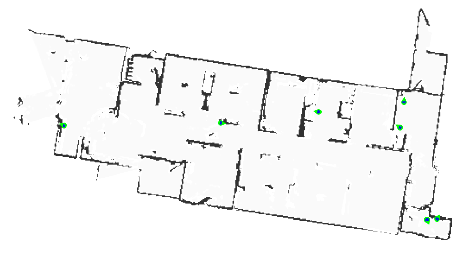
View of the floor plan map as it is captured by ScanPlan
For distances less than 3 m (9.8’), the map is dimensionally accurate to +/- 3 cm (1.2”). When the map is brought into FARO Zone software, length and area measurements can be quickly obtained.
The smartphone that controls the ScanPlan can also be used to take photographs of electrical panels, fire suppression equipment, FDCs (fire department connections) and other important details. The photographs are added to the map at the location where they are taken so that they can be viewed along with the map.

In addition, the Ricoh Theta 360° camera is available as an accessory to ScanPlan and is used to capture 360° panoramic photographs and attach them to the map. When used with panoramic viewing software, these photographs allow the user to explore every part of a room. The FARO Zone software includes a panoramic image viewer to display these 360° photographs.
Using ScanPlan saves hours over manual measurement methods, but what if the ScanPlan laser cannot contact a wall? This might happen if there are shelves or other objects in front of it. The easiest way to correct this is to bring the map into FARO Zone software where users draw lines, place symbols and insert text to show what is actually in the room. This is another example where taking photographs as you map is helpful to know how to complete the plan when you are back at the fire station.

Laser-scanned map from ScanPlan

FARO Zone software used to clarify details
More Than Just Floor Plans
Of course, as any pre-incident planning expert will confirm, blueprints and floor plan measurements alone are not enough to make sound, executable pre-fire plans. Bringing the measurement data from the ScanPlan into FARO Zone 2D software allows users to complete their plans, adding pre-drawn symbols that show critical items, including: doors, windows, sprinklers, FDCs, utility shut-offs, alarm panels, and more. Users can view the photographs taken with ScanPlan while scanning the building and add notes that might be helpful in the future. FARO Zone can also be used to add full details of the site including adjacent streets, closest fire hydrants, ideal staging areas, overhead power lines, etc.
When equipped with accurate pre-incident plans, Incident Commanders at the Banks Fire Department can make informed decisions and all first responders are better prepared to do their jobs quickly and effectively. The ScanPlan and FARO Zone software are ideal tools to help fire departments large and small create and maintain the up-to-date, detailed diagrams and images needed for successful incident pre-planning. Every minute spent creating pre-incident plans is justified by the potential to reduce property damage and ultimately save lives in an emergency.
“With tools like the FARO ScanPlan and FARO Zone software, it is much faster and easier for us to capture floor plans and keep them up to date,” Chief Linz added. “In a single afternoon, an intern was able to document the floor plans of the apparatus bay here at the station, a grocery store, and two other businesses. Then we used FARO Zone 2D to add all the details that turn a floor plan into a completed pre-incident plan.”
While it’s true the risk of structural fires might never fully be extinguished, it’s clear FARO solutions are proving an integral part of pre-incident planning. Whether in small cities like Banks, or larger metropolises the world over, failure to adopt such planning measures have repeatedly been found as a contributing factor to the loss of firefighter and civilian life. As must-have mobile mapping hardware and software products, it’s technology like this that’ll ensure something like Portland’s Great Fire of 1873 never happens again.

Step 1: Open the ScanPlan map in FARO Zone and trace the walls

Step 2: Select symbols and drop them into place

Step 3: Add notes and dimensions


